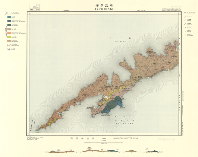
EXPLANATORY TEXT OF THE GEOLOGICAL MAP OF JAPAN Scale 1:50,000 IYOMISAKI Kochi, No. 67
By
(Written in 1957)
The area mapped is constructed chiefly of the Sambagawa met-amorphic rocks and ultrabasic rocks, which characteristic of "the Outer Zone of Southwest Japan".
Sambagawa metamorphic rocks are composed of crystalline schists, which show a comparatively low fissility. They strike generally NE-SW and dip to the south but partially to the north.
The apparent succession of the schistose rocks is as follows:
| Upper | 1. Iimestone |
|---|---|
| 2. alternation of green schist and limestone | |
| 3. upper green schist | |
| 4. black schist (with alternation of green schist and black schist) | |
| 5. sericite schist (so-called chlorite-graphite-sericite schist or graphite-chlorite-sericite schist) | |
| Lower | 6. Iower green schist(with hematite-quartz schist and many cupriferous pyritic deposits) |
Limestoneare found in the upper green schist at Kajitanibana and Kokajitanibana, and are about 200m in thickness. They are mostly grayish white or dark gray in colour, with green bands composed mainly of chlorite, and are locally whitish due to the impure materials.
Alternation of green schist and limestone is situated under the limestone, and is about 150 m in thickness.
Upper green schist is, generally, dark green in colour with yellowish green bands of epidote. It is composed chiefly of chlorite, quartz, epidote, sericite and hornblende in varying proportion, and contains augite sporadically. In many parts, hornblende and augite have a cataclastic structure, and are contained as relics. The parts of the banded structure composed of quartz and fibrous minerals, for instance, chlorite and sericite are especially fissile.
Black schist is usually so-called graphite schist, and is distributed as a belt from Nagatani to Dojibae, and as small exposures at Mitsukué and Satamisaki. The black schist distributed from Nagatani to Dojibaè varies from 300to400m in thickness, and that of other exposures is thin.
Black schist is usually highly fissile as compared with green schist, and shows many micro-foldings. In general, strike and dip are very various.
Black schist shows silky luster on the schistosity planes, and is composed mainly of quartz, and dusty graphite, with small quantities of sericite and chlorite.
Alternation of green schist and black schist is located in the eastern part of the black schist, and occurs as a small outcrop, which about 30 m in width and bordered by faults on both sides.
Sericite schist is mostly chlorite-graphite-sericite schist or graphite-chlorite-sericite schist. This schist lies usually between the black schist and the lower green schist, but is partially interbed-ded into the green schist as seen in the neighbourhood of Sata.
The rock is composed of sericite, quartz, chlorite and graphite. It is pale greenish black or pale grass green in colour, and shows silky luster on the schistosity planes.
Lower green schist covers the major part of the area, and is uncertain in thickness. When compared with the upper green schist, it is similar in mineral components and degree of metamorphism, but shows some characteristic features as follows :
A) The lowergreen schist is extensively exposed.
B) Many bedded cupriferous pyritic deposits occur in the lower green schist, but there is none of these deposit are founded in the upper green schist.
C) Layers of hematite quartz schist occurs in the lower green schist, but none of them are in the upper.
Hematite quartz schist is composed mainly of an aggregate of quartz grains, with small amounts of hematite, magnetite and sericite, but does not contain piedmontite.
Serpentine crops out at two places in the central part of the area. One is intruded into the black schist about 1 km southeast of Kamagi, and is nearly elliptic in form about 100m×50m. The other occurs as a small body in the lower green schist near Matsu. At both places, crystalline schists surrounding the serpentine are serpentinized, partly altered to talcose, and become very fissile.
Serpentine is dark green in colour, and consists mainly of chry-sotile, antigorite, chlorite, and a small amount of talc, apatite and opaque minerals.
Recent beds are distributed in valleys and beach. They are composed of sand, gravel and mud.
Cupriferous pyritic deposits are usually embraced in the lower green schist, and they are approximately concordant to the schis-to sity of the country rock. There are twenty mines as follows:
Oku, Takaura and Horaku
Kompira, Torii, Taisei, Oe, Kojima, Kochi, Akatsuki, Hirabae, Ashitani, Kamakoshi, Hinokuchi, Gendaura, Omisaki, Mukainada, Myojin, Matsuand Aoishi.
The ore deposits are 5 cm in average thickness, but are not yet clear in horizontal and dip side length. The ore shoots pitch down at 30° southwestward, showing similarity to the general pitch of lineation seen in the country rocks.
The wall rocks adjacent to the ore deposits are slightly chloritized. The ores are mostly massive, are in accompany with the disseminated ore of about 10 cm in thickness. They consist of pyrite with a small amount of chalcopyrite and sporadically with magnetite. The hand-picking ores contain 1.8~2% Cu and 35~38% S in average.
The production is about 9 tons since the beginning of the work-ing.
The mine is the largest in the area. The ore deposits are cut by a fault that run NW from Takaura to Kurobae, and the west side of the fault dislocates its position about 60m in horizontal distance to the south. The ore deposits extend about 250m in horizontal elongation in the east side of the fault, and about 450m in the west side. At mining part, the writers can observe the thickness of about 3m in maximum.
The extension of dip side is obscure.
The ore shoot pitch down at 16° toward the southwest, parallel to the general pitch of lineation seen on the country rocks.
The wall rocks adjacent to the ore deposits are chloritized, and are changed to pale green or white in colour.
The ore bodies are massive, banded and disseminated.
The massive ores occur in the central parts of ore deposits.
They consist of pyrite intimately mixed with rich chalcopyrite ore and magnetite are sporadically found, but the banded ores are found almost within about 20 cm near the boundary between the ore body and the mother rock. The ores also consist of pyrite intimately mixed with chalcopyrite, commonly accompanying with a small amount of hematite. The disseminated ores consist mostly of coarse-grained crystals of pyrite, and are usually not so rich in copper as the massive and banded ores.
Only the central parts of ore bodies are mined at present. The massive ores contain 1% Cu and 35% S in average, and the dissem-inated ores contain 0.5% Cu and 15% S. The ores containing 3.5% Cu are ratre.
The production of concentrate (2.8% Cu) treated by hand-picking is about 150 tons a month.
Deeper parts of the ore deposits are not observable, because most parts of the drifts are now sunk.
The exploration by means of vertical boring has certified a considerable amounts of remained ores in the east area of the mine.
The ore bodies are of two sorts, vein-like and disseminated. The former is about 5~20 cm in thickness and rich is copper. The latter is about 50 cm in average thickness and poor in copper, and is situated about 3.5m under the former. The horizontal extensions in strike and dip sides are uncertain.
The ores are massive and disseminated. The massive ores consist of pyrite intimately mixed with chalcopyrite sporadically accompany-ing with magnetite, but the disseminated ores consist mostly of pyrite witha small quantity of chalcopyrite. The grade of ores is variable.
The ore deposits are in the green schist, and is at the horizon about 20m upper than the layer of hematite-quartz schist.
The ore deposits now observable in the drifts are composed of disseminated and very irregular network ores, which have been almost oxidized. Some ores are rich in copper, but most ores are composed mainly of pyrite and poor in copper.
The ore deposits are in the northern wing of an anticline. They are 30~60 cm in thickness, and are composed mainly of coarse-grained pyrite with a small amount of chalcopyrite.
The deep parts of ore deposits are sunk.
1:50,000地質図幅説明書 (昭和32年稿) 伊予三崎 (高知-第67号)
伊予三崎図幅は,昭和26年度に行われた佐田岬半島西部と,同28年度に行われた愛媛西部地域との,層状含銅硫化鉄鉱床調査によって得られた地質図に基づき,若干補足調査を加えて作成したものである.
本図幅地域内に至るには,半島の南側では八幡浜から三崎村串に至る定期船の便があり,北側では冬の荒天期を除いては,喜多郡長浜町から神松名村二名津に至る定期船の便がある.
本図幅に含まれる地域は,愛媛県の西部豊予海峡に,細長く突出する佐田岬半島の西部にあたる.
陸地はほとんど山地からなり,急傾斜をなして海岸にせまる.とくに北海岸では,北西の季節風による波浪の侵蝕を受けて絶壁をなすことが多く,甚だしいものは崖の高さ60mに達する.
半島の脊稜は半島の延長方向と局部的には斜交するが,全体としてはほぼ平行し,北東から南西へ走る.
本図幅地域内の最高点は,三崎部落西方に聳立する海抜413.6mの伽藍山であるが,周囲に較べると高さはそれほど目立つものではない.伽藍山の東方には,海抜300m以上の山頂が連なり,またこれより西方は次第に低くなり,最西端部は海水面準から,高さ約20mの断崖となって終っている.
半島の北側海岸線には,南側海岸線には見られない多くの弯曲があるが,これは半島の延長方向とほぼ直交して走る,多くの胴切り断層の影響によって形成されたものと考えられる.
図幅地域内の大部分を占めて分布する岩石は,三波川変成岩類とこれを貫ぬく蛇紋岩であり,これらのほかには海岸近くの谷間および海岸に,現世堆積層が僅かに分布するのみである.
三波川変成岩類は,結晶片岩類から構成されており,四国中央部のものに較べて,一般に変成度は低い.変成岩類の片理は一般走向N60°E~E-Wで,地域西部にみられる褶曲軸の北翼および一部区域を除いては,傾斜はSEないしS20~50°を示す.線構造の落しはほぼS60°Wへ15~25°である.
三波川変成岩類は,見掛上つぎのように分けることができる.
| 見掛上の上部 | 1 石灰岩 |
|---|---|
| ↑ | 2 緑色片岩と石灰岩との互層 |
| ↑ | 3 上部緑色片岩 |
| ↑ | 4 黒色片岩(緑色片岩と黒色片岩との互層を含む) |
| ↑ | 5 絹雲母片岩 |
| 見掛上の下部 | 6 下部緑色片岩(赤鉄石英片岩を含み,層状含銅硫化鉄鉱床を胚胎する) |
変成岩類の最上部には,厚さ約200mのやや結晶質の石灰岩が挟まれていて,神松名村梶谷鼻および小梶谷鼻(比丘崎)の2カ所に露出している.本岩は一部には純白色の部分もあるが,一般には灰白色~暗灰色をなし,また緑泥石を主とする緑色鉱物からなる縞状部を挟むことがある.
石灰岩の下盤側には,下部を占める緑色片岩との間に,厚さ約150mに達する緑色片岩と石灰岩との互層帯がある.緑色片岩の縞は上盤側に近い部分では,厚さ10cm前後であるが,下盤側に近づくに従って次第に厚くなり,遂にはこの互層帯は緑色片岩に移化する.
名取部落から小梶谷鼻(比丘崎)の西方へかけて,石灰岩の下位に厚く分布し,また石灰岩の上位にも少しく露出する.本岩の石灰岩から下位の部分の見掛上の厚さは約250mである.
本岩は外観濃緑色を呈し,緻密,堅硬で片状構造に乏しいものと,やや剝理しやすいものとがある.両者は肉眼で識別することは,比較的に容易であるが,野外にわける産状からみて,両者を区別して取扱うことは困難であるために,地質図には緑色片岩として一括した.
緑色片岩は片理面に沿って,しばしば赤鉄鉱の薄層を挟む.
本岩は緑色角閃石・緑簾石および少量の普通輝石を含むが,これらの鉱物は自形を保っていることはほとんどなく,大部分は破砕構造を示し,ときには残晶を形成し,その大部分は緑泥石に変わっている.片状構造が発達している部分は,主として緑泥石と石英とが縞状に配列しているものである.
本岩は四ツ浜村長谷から三崎村童子碆に至る間に,厚さ300~400mをもって露出するほか,三机村三机附近および半島の突端部に分布している.
本岩は一般に石墨片岩と呼ばれているもので,主として石英からなり,少量の絹雲母・緑泥石・石墨などを含み,暗色~黒色を呈する.
本岩は一部では黒色粘板岩様を呈するが,一般には片状構造が発達し,とくに剝げやすくなっているものでは石英と絹雲母・緑泥石などが,交互に縞状構造をなして配列している.
本岩には一般に多くの褶曲構造が発達し,片理の走向および傾斜は変化に富み,また,軟弱で剝げやすくなっている部分には,レンズ状石英や石英細脈が挟まれていることが多い.
本岩類は上述の黒色片岩分布地帯の東部の海岸において露出し,厚さ約30mである.東西両端は断層によって断たれ,黒色片岩に接している.
ここで絹雲母片岩というのは,一般に石墨緑泥石絹雲母片岩,あるいは緑泥石石墨絹雲母片岩と呼ばれているもので,四ツ浜村長谷から三崎村佐田に至る間,および半島突端部附近に露出している.
四ツ浜村長谷から三崎村佐田の間に分布するものは,黒色片岩と下部緑色片岩との間に挟まれ(ただし佐田附近では黒色片岩と本岩との間には,厚さ約20mの緑色片岩が挟まれている),半島の突端部附近のものは,脊稜の頂部に露出しこの附近の最上部層をなしている.
本岩の厚さはかなり変化があるが,概して100m以下である.上部の黒色片岩に近い部分は淡い暗緑色を呈し,下部緑色片岩に近い部分は淡い草緑色を呈し,それぞれ上・下位層に漸移している.
本岩は主として絹雲母と石英とからなり,そのほかに少量の緑泥石・石墨などを混有している.普通片理面上では著しい絹糸様光沢を呈し,また,一部に滑石化している部分もある.
本岩は図幅地域内の大部分を占めて分布する.本岩は上部緑色片岩とほとんど同様の岩石であり,構成鉱物・片理などにあまり差異は認められないが,赤鉄石英片岩および層状含銅硫化鉱床は,すべて本岩層中に存在しているのが特徴である.
本岩は下部緑色片岩中に介在する.石英を主とし,少量の赤鉄鉱および磁鉄鉱などを混有し,紅簾石をほとんど含まない.著しく剝げやすく,緑色片岩との境では,これと縞状をなす漸移帯が生じている.
本岩には地域東半部の北海岸に分布するものと,西半部の南海岸の三崎村赤碆附近に分布するものとがあるが,これらはほぼ同じ層準に位置するもののようである.東半部の北海岸のものは,南北方向の小規模の緩い波状褶曲のために,繰り返し露出しているもので,東端部の三机以東の隣接図幅地内では,海面下に没する.
本図幅地域内の露出は,僅かに2カ所にすぎない.その1つは黒色片岩地帯の東部においてこれを貫ぬき,大体長径100m,短径50mのほぼ随円形をなして露出し,他の1つは地域中央部の北海岸松部落の,西方約300mの沢中にきわめて狭く露出し,緑色片岩を貫ぬく.
いずれの露出においても,本岩から外側へ向かって50cm~数mの間は,蛇紋岩化して淡緑色を呈し,一部は滑石化している.
蛇紋岩の大部分は外観暗緑色で,主として温石綿・陽起石・緑泥石・角閃石などからなり,これらのほかに少量の磁鉄鉱・滑石・燐灰石などが含まれている.
本図幅地域内は,地形が急傾斜をなしている所が多いので,現世堆積層の分布する範囲はきわめて狭い.通常,海岸近くの谷間および海岸にきわめて狭く分布し,主として砂・礫・泥土などから構成されている.
本図幅地域は小規模の地塊運動を受けており,ほぼ南北および東西に走る多くの断層がある.これらは佐田岬半島の形成に,大きな役割りを果したものと思われる.
南北性の断層は,半島の北方の海中を通る中央構造線とほぼ直角に,東西性の断層はほぼこれに平行して走るもののようで,これらの断層は中央構造線の運動に関係して生成されたものと考えられる.
この種の断層があると,この西側は東側に対して関係位置が上方に変位していることが多い.これは地質の層準によるだけでなく,若干の例外はあるが,海岸線が,断層の西側が海に向かって突出していることが多いことからもうなづかれる.三崎村野坂附近の地形はその好例である.
南北方向に走る多くの断層の西側が,上方に変位していることは,狭長な半島が形成された原因の一つとなっている.
断層の多くは変位の規模は明らかでないが,高浦から黒碆を通る断層では水平変位は約60mである.
垂直運動の著しいものは,黒色片岩の東端部をなしている南北性の断層で,この西側は見掛上北方へ変位した結果,ここには最上部岩層である黒色片岩類が見られるが,東側には露われない.
褶曲のなかで規模の大きいものとしては,半島西半部の延長方向と僅かに斜交して,概してS40~60°Wへ10~20°落している背斜軸がある.このほかには著しいものはないが,半島東半部には多くの小規模の波状褶曲があり,その褶曲軸は水平に近く,これは赤鉄石英片岩の分布に,大きな影響を与えていることは前に述べた通りである.
本図幅地域内の地下資源は,含銅硫化鉄鉱を主とする.地域の中央部にはやや厚い石灰岩があるが,規模が小さく,既述のように不純物を多量に混有している部分が多いので,稼行に堪えうるかどうか疑問である.
次のような多くの鉱山があるが,このうちには長い間休山して,坑道は崩壊して入坑できないものが多い.鉱床はいずれも下部緑色片岩中にあって,その片理にほぼ平行に胚胎する.
| 番号 | 鉱山名 | 所在地 |
|---|---|---|
| 稼行中の鉱山 | ||
| 1 | 大久鉱山 | 愛媛県西宇和郡四ツ浜村大久 |
| 2 | 高浦鉱山 | 愛媛県西宇和郡三崎村高浦 |
| 3 | 宝楽鉱山 | 愛媛県西宇和郡三崎村串 |
| 休山中の鉱山(入坑可能な鉱山) | ||
| 4 | 金比羅鉱山 | 愛媛県西宇和郡三机村小島 |
| 5 | 鳥井鉱山 * | 愛媛県西宇和郡三崎村鳥井 |
| 入坑不可能な鉱山 | ||
| 6 | 大成鉱山 | 愛媛県西宇和郡三机村土倉 |
| 7 | 大江鉱山 | 愛媛県西宇和郡三机村大江 |
| 8 | 小島鉱山 | 愛媛県西宇和郡三机村小島 |
| 9 | 河内鉱山 | 愛媛県西宇和郡四ツ浜村川之浜 |
| 10 | 暁鉱山 | 愛媛県西宇和郡三机村平碆 |
| 11 | 平碆鉱山 | 愛媛県西宇和郡三机村平碆 |
| 12 | 釜越鉱山 | 愛媛県西宇和郡神松名村二名津 |
| 13 | 足谷鉱山 | 愛媛県西宇和郡神松名村二名津 |
| 14 | 火ノ口鉱山 | 愛媛県西宇和郡神松名村二名津 |
| 15 | 源田浦鉱山 | 愛媛県西宇和郡神松名村二名津 |
| 16 | 御三崎鉱山 | 愛媛県西宇和郡三崎村井之浦 |
| 17 | 向灘鉱山 | 愛媛県西宇和郡三崎村向灘 |
| 正確な位置不明の鉱山 | ||
| 18 | 明神鉱山 | 愛媛県西宇和郡神松名村 |
| 19 | 松鉱山 | 愛媛県西宇和郡神松名村 |
| 20 | 青石鉱山 | 愛媛県西宇和郡四ツ浜村 |
* 鉱山名不明のため便宜上部落名を使用した.
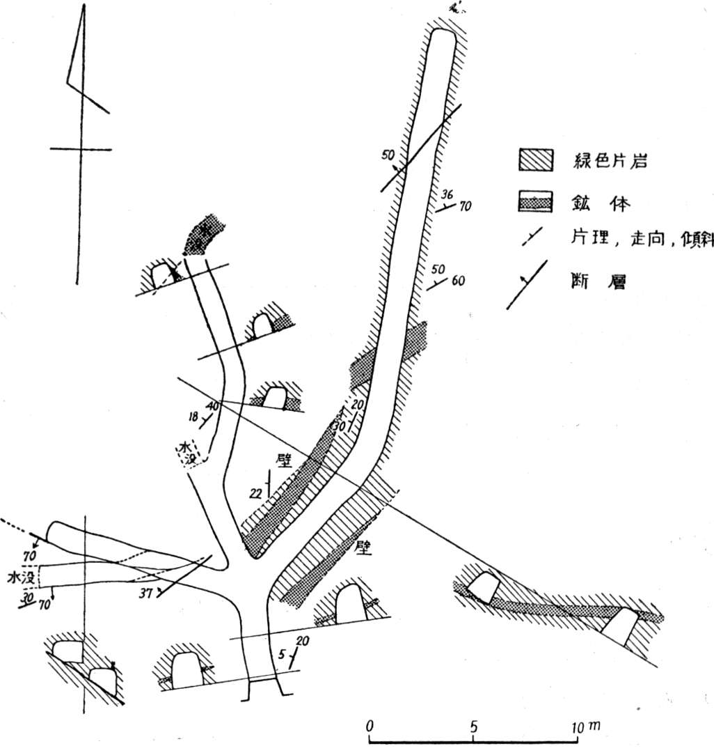
大久部落の西方約600m,同部落から名取部落へ通ずる道路の下方,坑口は海面上6m附近に2坑ある.
本鉱山は昭和24年4月に操業を開始し,上下2坑のうち,調査当時は上部坑道だけ探鉱し,鉱石は手掘り,手選され,坑口の下方の海岸から船積みされていた.調査当時は従業員7名,始業以来調査当時までの出鉱量はCu 1.8~2%,S 35~38%の鉱石約9 tであった.
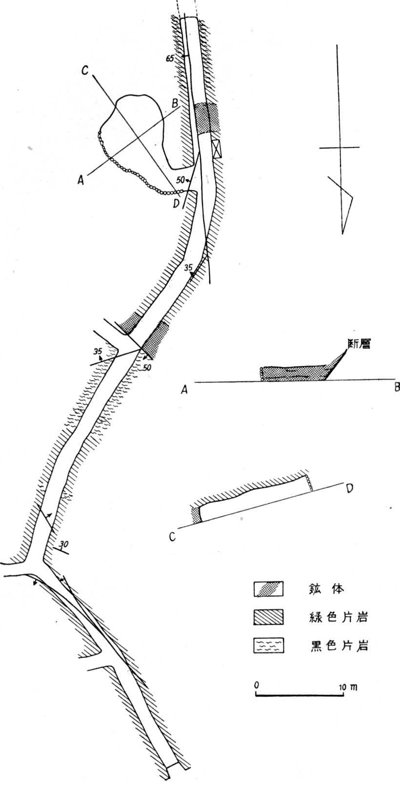
鉱山周辺は緑色片岩からなり,その走向はN40~75°E,傾斜30~60°SE,線構造の落しはS70°Wへ30°前後である.坑内には数条の断層があり,その走向はN40~60°EまたはN50~70°Wで北または南へ30~70°傾斜する.
このなかには鉱体を切り,やや規模の大きい正断層がある.
鉱体は母岩の片理にほぼ平行に近く,雁行状に配列する数枚の薄い鉱体からなる.鉱体の厚さは普通5cm内外で,大部分は黄鉄鉱を主とする塊状鉱からなり,時には厚さ約10cmの鉱染状鉱を伴なう.前者はまれに20cm以上に肥大することがあるが,多くは長径1~2mのレンズ状で終っている.一般に塊状鉱が肥大する場合には,その部分では鉱体と母岩との境界と,母岩の片理とは斜交する場合が多い.
鉱石は黄鉄鉱を主とし,僅かに黄銅鉱を混える含銅硫化鉄鉱で,局部的にはCu 7%以上の高品位の部分もあるが,一般にはこのような鉱石はきわめて少ない.また局部的に黄銅鉱をほとんど含まない.素硫化鉱の部分もある.
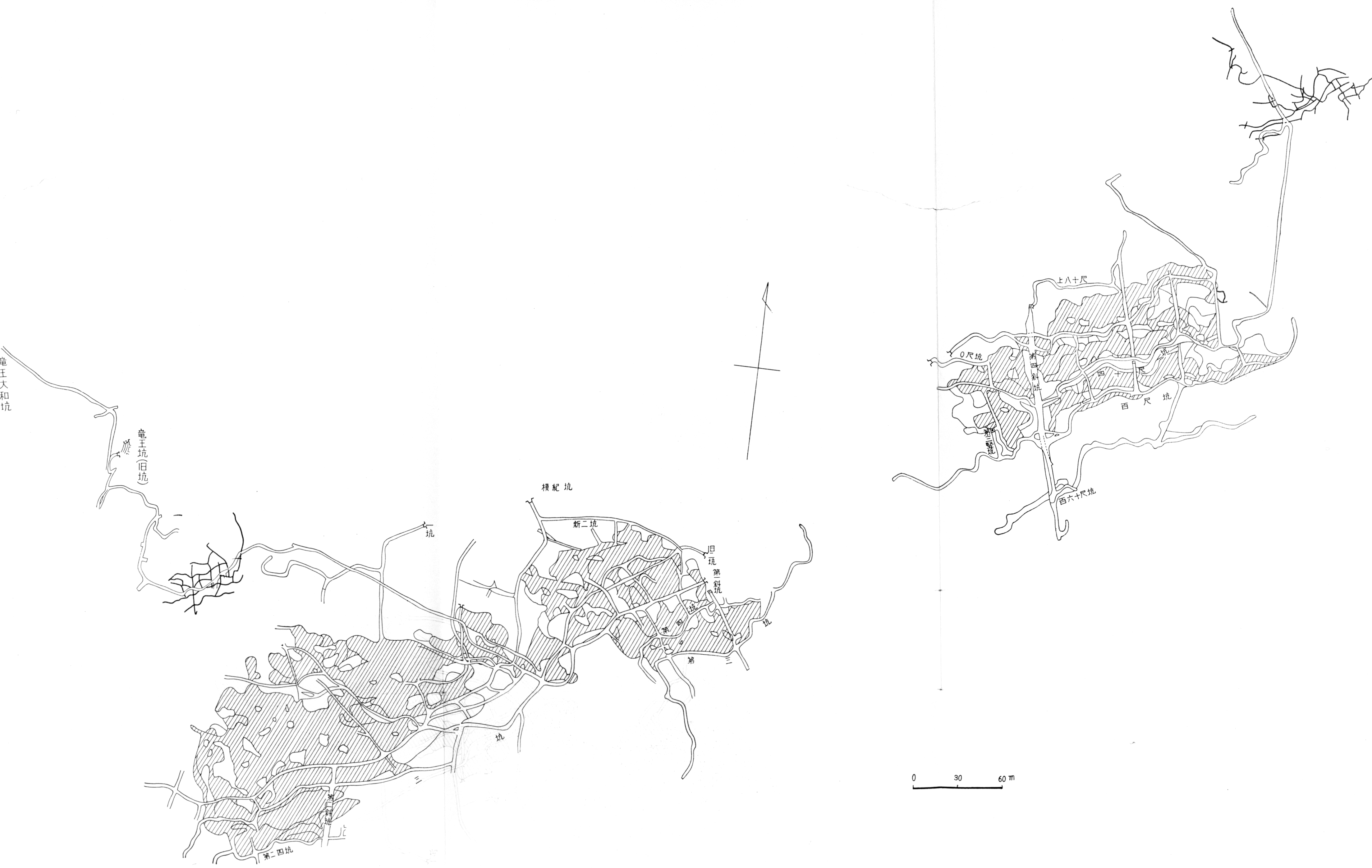
本鉱山は高浦部落内の西端部にある.主要運搬坑道の坑口は海岸に近く,海面から約2mの高さにあり,鉱石の出荷はきわめて便利である.
本鉱山は本図幅地域内ではもっとも規模の大きいもので,明治43年8月に藤野亀之助によって採掘権が設定されて以来,幾多の変遷を経て,昭和27年10月から藤本光明によって再開された.
調査当時は水没している下部坑道を取明け,一部で採掘した鉱石を,船積みによって佐賀関製煉所へ送っていた.出鉱量はCu 2.8%の鉱石約150 t/月であった.
鉱山附近の地質は緑色片岩・黒色片岩・絹雲母片岩および赤鉄石英片岩などからなり,これらの片理の一般走向はN75°E,傾斜はS32°,線構造はS50°Wへ16°内外の落しを示す.
鉱床は絹雲母片岩から約80mの下位層準にあたる下部緑色片岩中に胚胎する.鉱床の上位20mおよび下位80m附近には赤鉄石英片岩がある.
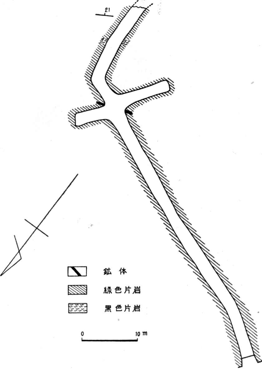
盛業当時の坑内図(第2図)によれば,かつて採掘された範囲は東西2区域に分かれ,東部区域では約250m,西部区域では約450mの走向延長を示す.この両区域間には断層があって,西部区域は相対的に水平距離約60m南方へ転位している.
本坑坑道(第3図)には,崩壊部の手前約15mに採掘場があり,ここでみられる鉱体は厚さ約1.5m,このうち銅品位のやや高い塊状鉱は,厚さ約80cmで鉱体のほぼ中心部にあり,上下は縞状鉱および鉱染状鉱からなる.
塊状鉱の品位はCu 1%内外,S 35%内外,ときにはCu 3.5%に達する部分もある.鉱染状鉱の品位はCu 0.5%内外,S 15%内外が多い.
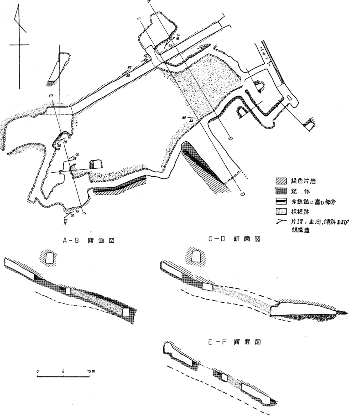
当時もっともよく調査できたのは,運搬坑道から下部(第5図)で,もっとも広い採掘場があり,北東方から南西方へ約46m,北西方から南東方へ約40mである.鉱体の最大の厚さは約3mに達し,一般に鉱体のうちその上・下盤に近い部分には黄鉄鉱を主とする鉱染状鉱,縞状鉱などを伴ない,採掘の対象となるのは中心部である.
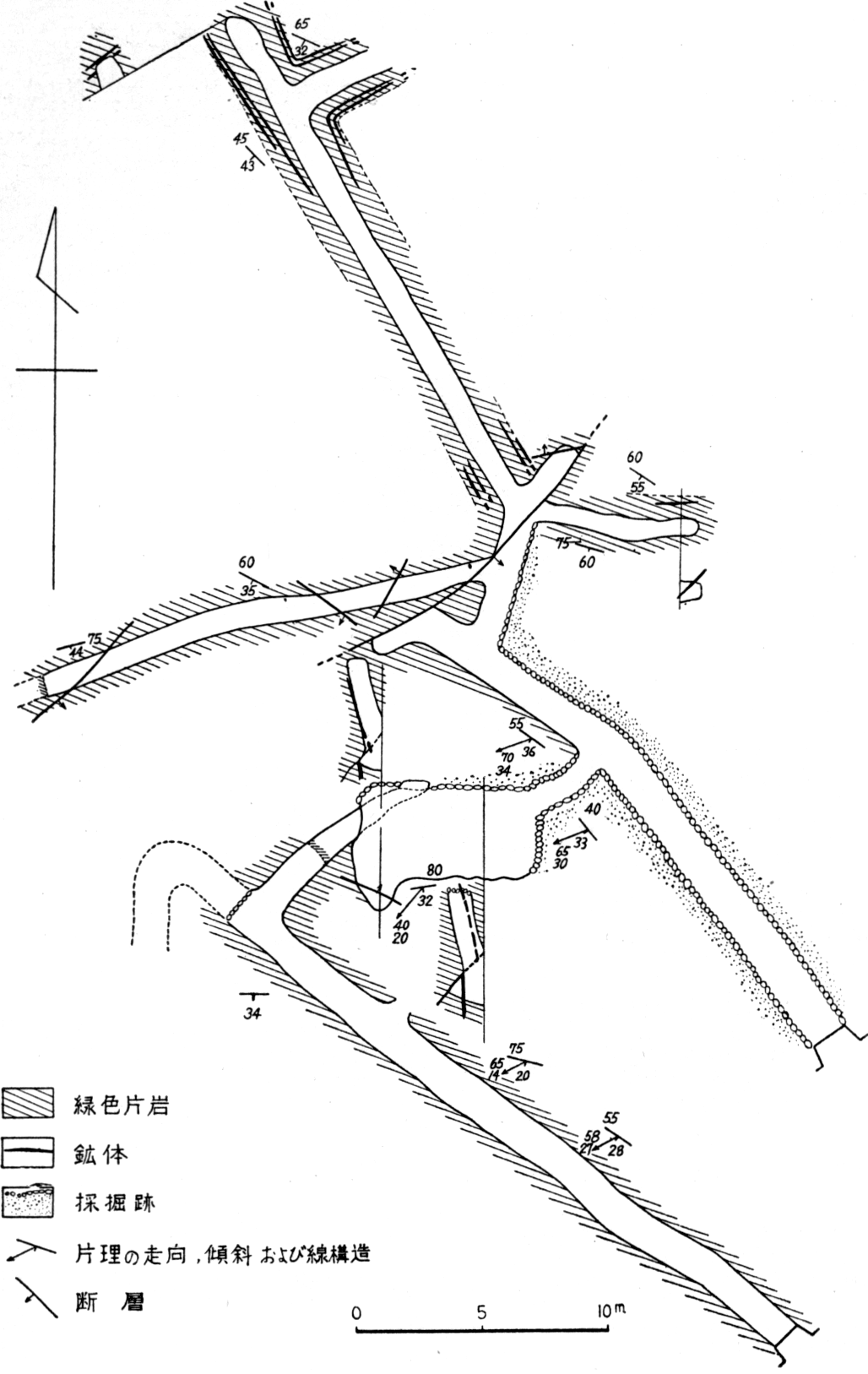
本鉱山は三崎村串部落の南側,海岸に面する.往時盛大に稼行された跡はほとんど崩壊して,僅かに2,3の旧坑口が見られるにすぎない.現在稼行しているものは,以前に採掘された部分の北東方約200mにあたる.
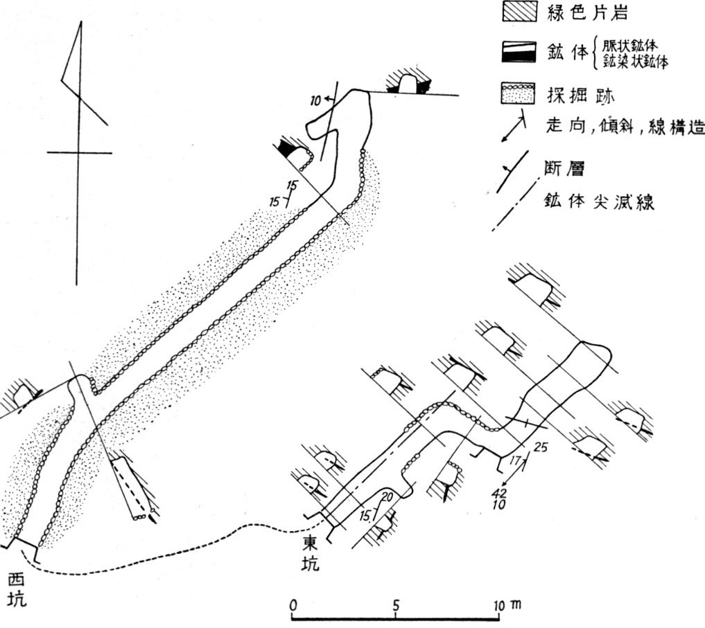
坑口は半島の南側海岸に面し,海面上約10mにあって,東坑および西坑がある.本鉱山は東方鉱業株式会社が,昭和28年から操業を始めたもので,調査当時には僅か1名で作業を行っていたに過ぎない.
本鉱山周辺の地質は,主として緑色片岩によって構成され,局部的に黒色片岩の薄層が挟まれている.これらの岩類は一般走向N15~25°E,傾斜NW15°内外,線構造はS45°Wへ10°の落しを示す.
鉱床は,緻密,塊状でやや銅品位の高い脈状鉱体と,その上盤3.5m附近にあって,黄鉄鉱を主とする厚さ約50cmの鉱染状鉱体とからなる.前者は東坑,後者は西坑によって採掘されている.
坑内図に示すように脈状鉱体の西部は,東坑坑道附近で終り,これから西方には続かない.これに反して,北東方上部へはなお連続する見込みであるが,現在以上のものを期待することは困難と思われる.
三机村小島部落の北西方約500mの赤崎にあり,坑口は海岸に面した急傾斜の山腹に開坑されている.
鉱山附近の地質は,下部緑色片岩と赤鉄石英片岩とからなり,片理の一般走向はN75°E~N60°W,傾斜N5~20°,線構造はN40°Wへ5°内外の落しを示している.
鉱床は赤鉄石英片岩の上位約20mの,下部緑色片岩中に存在する.鉱体は厚さ約5cmで,鉱染状鉱からなり,大部分は酸化して「赤ヤケ」を呈する.
坑口の貯鉱のなかには,銅品位のやや高いものが見られた.
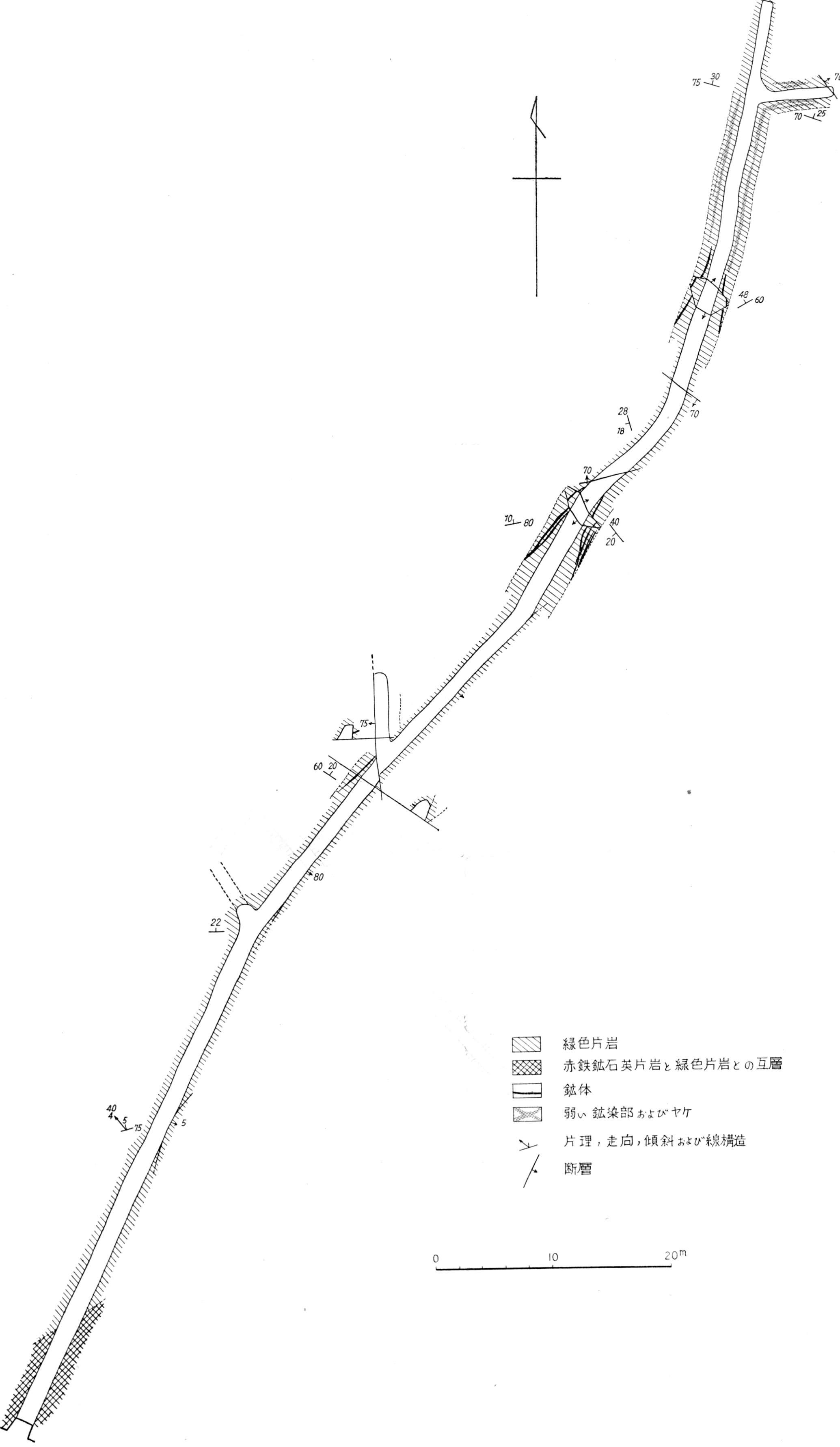
三崎村鳥井部落の北東方,三崎部落から串部落へ通ずる道路の上方10m附近に坑口がある.開発の時期などはまったく不明である.
本鉱山の位置は,神松名部落から三崎村大碆を通る背斜軸に近く,複褶曲部にあたり,母岩は走向N-S~N70°E,傾斜WないしNW5~25°の波状褶曲をなし,鉱床もこれとともに波状に屈曲している.坑内には走向N50°E前後の断層があり,なかには鉱体を切っているものもある.
鉱体は主として,粗粒の黄鉄鉱からなり,坑口附近での厚さは,塊状鉱は約5cm,鉱染状鉱は約30cmである.また,坑道の分岐点から奥の方では,厚さ約60cmに肥大しているが,全般的には大した変化はない.
西方下部坑道は下部が水没していたので,詳細は不明であった.